Photos, articles and places from "Around Bamford" Rochdale from Victorian times up to the 1970s and the present day.
Thursday, 8 April 2021
Jacob's Well near Littleborough, Lancashire
At the side of the A58 Halifax Road (SD 9638 1706) and close to Blackstone Edge
Roman road, near Littleborough, not far from the Lancashire and Yorkshire
border, is the now almost forgotten ‘Jacob’s Well’, a sacred spring that is
hidden in the grass and fearns at the side of the busy, windswept moorland road
that links the two counties. Some 280 metres east of the well is the so-called
Roman Road that climbs over Blackstone Edge and then heads to the fort at
Ilkley. Presumably the Roman soldiers who marched along this Roman road knew of
the presence of this ancient spring, which they may have even dedicated to one
of their gods and, before that, the Celts would have also recognized it as a
sacred spring. In more recent times it has acquired the dedication to Jacob, who
might be the biblical prophet of the Old Testament? and is sometimes called St
Jacob by Orthodox Churches. The well is to be found about halfway up the A58
road (right-hand side) and just 100m past where a wooden gate and footpath leads
off to the east to meet up with the Roman road. At the top of the A58 road, on
the opposite side, is the well-known landmark White House public house. The west
Yorkshire border is further along the road.
At the front of the well there is a very long sandstone slab that has the
inscription ‘Jacob’s Well’ carved onto it and some other letters just below
that, but it is difficult to tell what this says. It looks as though the
inscription was carved in more recent times. The water is held in what looks to
be a large and deep stone trough just behind the carved slab, but there is much
foliage surrounding the well and so it is difficult to give any measurements. On
the day of my visit the water was slimy green in colour and most certainly “not”
drinkable.
There doesn’t appear to be any record of this well, whether it be holy or
sacred, is not really known and the dedication to Jacob is uncertain. It could
perhaps be named after the Biblical Jacob (Yacob) who was the Hebrew prophet and
patriarch of the Old Testament. He is venerated as St Jacob by the Orthodox
Churches. There are other wells named after Jacob, one at Bradford, west
Yorkshire, and another at Matlock Bath, Derbyshire, but there are a few others
in England. The name “Jacob” is also “James”, so these wells could be dedicated
to a person with that name, perhaps even St James of Compostela?
Sources & Related Websites:-
https://en.wikipedia.org/wiki/Jacob
https://thejournalofantiquities.com/2017/06/16/jacobs-well-near-littleborough-lancashire-yorkshire-border/
Copyright © RayS57, 2021
Friday, 26 March 2021
Around Watergrove Reservoir near Wardle, Rochdale, Greater Manchester
On the windswept Pennine moors to the north of Wardle, near Rochdale, in Greater
Manchester, is Watergrove Reservoir. The reservoir was constructed back in the
1930s in order to supply water to nearby Rochdale, which was short of water in
times of drought, but the old village of Watergrove very sadly had to be
abandoned and sub-merged beneath the waters of this new reservoir. Watergrove
village itself came into being in the first half of the 19th century with at
least three mills providing work for the good folk of Wartergrove and probably
some from Wardle; there was also a Methodist church, and a public house! and,
eventually by about 1870 300 people were living in the village. However,
children from the village had to go to Wardle as there was no school.
Going further back into the history of Watergrove there were several farms
dotted around, mainly dating from the 1700s, but one from as far back as 1640.
But the cotton mills that were built in and around Watergrove after 1840 were
what undoubtedly caused the village to flourish during the 19th century. The
millworkers lived in rows of cottages in the village; they attended the church
on Sundays, and maybe went to the pub when they had the time and the money. Life
was quite good but also hard for the cotton workers here for they worked long
hours, but, the good folk of Watergrove village were a 'very big part' of the
Industrial Revolution in the Rochdale area in the Victorian Age. But, by the
early part of the 20th century the mills began to decline and by about 1930 had
finally closed; the village of Watergrove then also fell into a slow depression,
with some of its inhabitants moving away to the nearby towns, while hundreds of
local men were employed in the construction of what would be the final nail in
the coffin, the reservoir itself.
In 1938 the once vibrant community of Watergrove had gone forever, sunk beneath
the waters of the reservoir, the foundations of its long-forgotten farms and
other buildings only reappearing when the reservoir's waters are at a very
low-level in long spells of dry weather. On the south-eastern bank of the
reservoir there is 'The History Wall' or Wave Wall with many interesting carved
stones and date-stones from the old village built into it. Today Watergrove
Reservoir is a place to go to for walking - there are indeed many paths and
trails in the area and, there are footpaths running around the edges of the
reservoir. The Rochdale Way runs just to the west. There is car-parking at the
south-side of the reservoir (SD 91169 17649). The History Wall is 100 metres
east of the carpark.
Watergrove Reservoir is the largest in the Rochdale area and is situated some
240 metres (787 feet) above sea-level. From west to east it is 846 metres (2,775
feet) in width and from south to north 1,245 metres (4,084 feet) in length.
Sources & Related Websites:-
https://www.geograph.org.uk/photo/2289430
https://www.geograph.org.uk/photo/2290199
https://lancashirepast.com/2019/09/01/watergrove-reservoir-and-drowned-village-wardle/
http://www.abandonedcommunities.co.uk/rochdale3.html
https://www.visitrochdale.com/things-to-do/watergrove-reservoir-p12901
https://getoutside.ordnancesurvey.co.uk/local/watergrove-reservoir-rochdale
Copyright © RayS57, 2021
Friday, 5 March 2021
Rochdale Castle.
There used to be a castle in Rochdale!, well there was way back in the 11th
century, but by the early 13th century it had been abandoned. It's possible
there was an earlier, Saxon settlement, on what is now Castle Hill. The motte
and bailey castle had stood on a raised, steep-sided area of land at the south
side of the River Roch, to the west of Rochdale town centre at SD 89164 12851.
The area around Castle Hill is also known as Castleton - which means 'Castle by
a farmstead or settlement' - and is a post-Conquest place-name.
A motte-and-bailey castle is a fortification with a wooden or stone keep
situated on a mound called a motte, which may have had a walled courtyard on one
side, or a bailey; this in turn was surrounded by a defensive ditch and a wooden
palisade. This raised, tree-covered area of land, above Manchester Road, is
called Castle Hill, and on its summit where the Medieval fortification used to
be there is a large 19th century house with a Georgian facade; an earlier
building from the early 1600s had also stood on this site. Henry Fishwick's plan
(above) from 1823 clearly shows the steep-sided defensive ramparts and layout of
Castle Hill.
Before and after the Norman Conquest of 1066 the Saxon thegn, Gamel, Lord of the
manor of Recedham, may have occupied the castle above the river Roch; he also
built the church of St Chad. Gamel was the father of Orm. At the time of the
Domesday Book (1086) Gamel owned land in the north-west of England including
Rachedal. He was one of the 21 men in the Saxon Salford Hundred area, of which
Rochdale was a part. The Domesday Book goes on to tell us that Gamel retained
two carucates of land in Rachedal in 1086. Gamel also owned the manors of
Heywood and Radcliffe.
There is nothing left of Rochdale's Medieval Castle today. However, at Castle
Hill some of the earthworks of the steep-sided defensive banks or ramparts can
still be seen, especially at the north side, north-west side, north-east,
south-west and western sides, some of which are still quite extent; the bank at
the south-eastern side now much denuded and lost to the road layout (Manchester
Road), as well as a row of houses which were demolished, and the driveway upto
the house. There are no traces of the motte-and-bailey castle on the top of
Castle Hill - the site being occupied by the house and other buildings - as well
as more recent features such as the new housing estate called Castle Hill
Crescent. There used to be a church at the far south-western side of the hill
but this has gone.
Long after the death of Gamel in the early 13th century, just before the year
1212, King Henry II granted the manor of Rachedam (Rochdale) to Roger de Lacy
whose family retained it as part of the Honour of Clitheroe until it passed to
the Dukes of Lancaster by marriage and then by 1399 to the Crown, according to
the Wikipedia website. Whether Rochdale Castle was ever re-occupied at a later
time is not known.
Sources & Related Websites:-
https://lancashirepast.com/2020/02/22/rochdales-lost-castle/
http://gatehouse-gazetteer.info/English%20sites/3023.html
https://www.pastscape.org.uk/hob.aspx?hob_id=45159#:~:text=The%20motte%20and%20bailey,%20built%20in%20the%20early,from%20North-South%20by%20100%20feet%20East%20to%20West.
https://en.wikipedia.org/wiki/Rochdale_Castle
https://rays57-aroundbamford.blogspot.com/2018/01/around-st-chads-church-rochdale.html
Copyright © RayS57, 2021
Wednesday, 10 February 2021
Blackheath Circle, Near Todmorden, West Yorkshire
About 1 mile north of Todmorden, west Yorkshire, near the southern edge of
Todmorden Golf Course at (SD 94339 25434) there is a Bronze Age cairn circle,
ring cairn or round barrow. This is usually referred to as Blackheath Circle,
but locally it is called Frying Pan Circle, because of its circular shape. It
has also been called Roman barrow in the past. It also sometimes goes under the
name 'Blackheath Ringbank Cemetery'. This quite large circular feature is now
incorporated into the level part of the golf-course, however at ground-level it
is hardly noticeable today apart from a slight raised bank at either side of the
circle; the north side being very denuded. The grass is often a brownish colour
where the cairn's outer raised ring shows up after being mowed. Blackheath cairn
circle is situated at over 900 feet above sea-level. When it was excavated in
1898 nineteen burial cists were discovered along with a number of cremation
urns, food vessels and grave-goods. Very sadly, though, this ancient site is now
part of the golf-course - of all things!
Blackheath Circle is best reached from Kebs Lane, Eastwood Road and then Hey
Head Lane, which goes past the golf course. About halfway down the lane on the
right-hand side there is a wall-stile and a footpath running west beside a wall
at the eastern edge of the course. The Bronze Age cairn circle is 350m along
this path through the trees and, at the far end, just in front of the large gap
in the wall running across.
The following information is taken from 'Life In Bronze Age Times - A Resource
Book For Teachers'. It says of the site: "Blackheath is a Prehistoric cemetery
situated at 940 feet (287) O.D., on a south facing slope. On excavation it was
found to comprise a circular bank of earth 3 feet (1m) high in which large
stones were regularly arranged. The circle was 100 feet (30m) in diameter. There
was no obvious entrance. A circular area with a floor of beaten clay was
enclosed by the bank. There were cairns both inside the circle and in the earth
bank. These revealed pits and cists containing cremation burials. Nineteen were
found in all. Some of the cremations were found in urns. The urns were all
upright and buried just below the surface. A characteristic feature of the urned
cremations was the use of a small inverted vessel placed upside down in the urn
and serving as a lid. The central urn is 11 inches (20 cm) high. The collar
shows impressions made by twisted cord. As well as bones, the urn contained a
small decorated pygmy vessel . In this vessel there was a bronze dagger, a bone
pin and a bronze pin.
Another urn also contained a pygmy vessel together with beads of faience, amber,
jet and shale, two bone pins, flint flakes and a leaf shaped arrowhead. Two of
the urns were covered by other vessels, one of which may have been a food
vessel. With the exception of the two urns in the bank, all the finds were in
the eastern half of the circle. In the rest of the circle there were areas where
the floor showed evidence of being baked by a great heat. These were covered
with a layer of charcoal 1-2 inches thick. It was suggested that these may have
been the areas where the bodies were cremated. Two deep pits were also found,
possibly the holes where clay was dug out of the ground for making the pots.
Areas of coarse sandstone were discovered. This could have been used for
grinding down and mixing with the clay. There was at least one (possibly four)
kilns. These were cist-like structures surrounded by baked floors where the
pottery was fired."
There is another "possible" circular feature just to the east of the large cairn
circle at SD 94454 25507. However, this almost destroyed circle is smaller and
very difficult to make out as it is now, sadly, incorporated into a raised
golfing barrow, but the outer ring of this circle often shows up at one end as
brownish grass in the summer months, especially where the golfing barrow slopes
down to ground level.
Sources & Related Websites:-
Bennett, Paul, The Old Stones of Elmet, Capall Bann Publishing, Milverton, Somerset, 2001.
Thomlinson, Sarah & O' Donnell, John, Life In Bronze Age Times - A Resource Book For Teachers, Curriculum Development Centre, Burnley.
https://thejournalofantiquities.com/2017/02/10/blackheath-circle-near-todmorden-west-yorkshire/
http://www.calderdale.gov.uk/v2/residents/leisure-and-culture/local-history-and-heritage/glimpse-past/archaeology
http://www.pastscape.org.uk/hob.aspx?hob_id=46095
Copyright © RayS57, 2021.
Monday, 25 January 2021
Around Deeply Vale Mills & Wind Hill Colliery, Cheesden, Near Rochdale, Greater Manchester.
The Industrial Revolution came to the Cheesden Valley, north of Rochdale, in the
late 18th century and flourished in the 19th when fourteen mills were built
here, although they were not wholly reliant on the Cheesden Brook itself - the
course of which runs in a south-easterly direction from Four Acre mill above
Cheesden Pasture mills in the north to Simpson Clough in the south - these mills
being for the most part steam-driven. The place-name Cheesden means 'gravel
valley', though parts of it are gorge-like. The area soon became an Industrial
enclave or Cradle of Industry with thousands of local people from the nearby
towns and villages working in the mills, which were at their heyday in the
middle of the 19th century; the workers' youngest children being sent to school
at Buckhurst school-cum-chapel, just a short distance to the north (after 1840)
which was opposite Longlands Mill and its lodge. To the Industrial Archaeologist
the mill ruins alongside the Cheesden Brook are like paradise! Deeply Hill, also
known as Deeply Vale Upper mill, is located at (SD 8230 1488), while just to the
south is Deeply Vale Lower Mill at (SD 8242 1455).
These cotton-spinning mills, paper and print mills, and bleach and dye works, in
particular, those at Deeply Vale Upper (formerly known as Deeply Hill) and
Deeply Vale Lower, were supplied with coal from Wind Hill Colliery (SD 83105
15220) on the Ashworth Road, 1 mile to the east. Deeply Hill mill became
Hardmans in 1867. It closed after 1890. Coal was supplied to Deeply Vale mills
by means of a tramway over the Ashworth Road and then crossing the moorland from
the colliery at Wind Hill; it eventually reached the mills in wagons (carriers)
over a wooden trellis viaduct and overhead rope and pulley system, which would
have been very ingenious for its time.
The Cheesden Valley has, in more recent times, been referred to as 'The
Forgotten Valley', but maybe not so much forgotten today! However, today not
much is left of the mills and workers cottages at Deeply Vale apart from the
bare overgrown ruins of these once mighty industrial buildings that paved the
way for the Industrial Revolution in the Cheesden Valley. By the end of the 19th
century and the early 20th it was the end for the mills in the valley; they were
closed and abandoned forever with nature slowly consuming the buildings, which
became ghostly ruins. Peace returned to the valley. However, some of the mill
workers dwellings continued to be occupied right up until 1960. And equally
there is not much left of the former Wind Hill Colliery on the Ashworth Road
apart from the square-shaped perimeter earthworks and foundations of
coal-working buildings and pit shaft etc.
You can walk south along a country lane (Croston Close Road) from Cheesden Bar
(SD 82259 16563) on the A680 (Edenfield Road) for about 4-5 miles passing the
now peaceful and solitary ruins of Bridge Mill, Cheesden Lumb mills, Croston
Close mills, Longlands mill and its lodge, and the former Buckhurst school and
chapel, which is now a private house. Continue walking south-south-east through
Deeply Vale with the Cheesden Brook on your left as well as the mill lodges.
Here one can see some enormous dressed stones among the overgrown foundations,
all that remains of the two former mills; also the Almonds residence. Continue
south along the main footpath passing the ruins of Washwheel Mill Lower
(Almonds) to Birtle Dene Mill and Kershaw Bridge Mill (Allansons) - ending up at
Simpson Clough Mill (SD 85217 12140) which is still in use today. Hooley
Bridge is just a little further along on the Bury-Rochdale Old Road.
Sources and related Websites:-
Clayton, H. D., A History of Ashworth near Rochdale, Ashworth Hall, Rochdale,
1979.
Sandiford, A. V., & Ashworth, T. E., The Forgotten Valley, Bury and District
Local History Society, 1981.
https://en.wikipedia.org/wiki/Cheesden_Valley
Photo of Deeply Hill and Deeply Vale by Bill Boaden:
https://www.geograph.org.uk/photo/1875969
Photo: Remains of Deeply Vale print works by Liz Dawson:
https://www.geograph.org.uk/photo/380469
https://www.heywoodhistory.com/2016/02/the-lost-mills-of-cheesden-valley.html
Copyright © RayS57, 2021.
Wednesday, 13 January 2021
Affetside Cross, Near Bury, Greater Manchester
OS Grid Reference: SD 75471 13676. At the edge of Affetside village green, near
Bury, Greater Manchester, stands an old cross of uncertain date. It is probably
Medieval but, because it stands on the old Roman road (Watling Street), some
historians have even considered it to be a Roman cross or milestone, or even a
Roman column, but that seems unlikely. It is probably a pilgrims cross. Watling
Street runs southeast from Affetside towards Manchester, and northwest in the
opposite direction towards Ribchester. The village green has some modern
standing stones and a large pond. Affetside Cross is best reached from the A 676
(Ramsbottom road) and then southeast for ½ a mile along the almost
straight-running lane that is the Roman road, bringing you into the picturesque
little village, where you’ll find the old cross beside the green – you can’t
really miss it.
Affetside cross is about 4¼ feet high on its three steps, well actually two
steps, as the top step is in effect the base which the gritstone shaft is
socketed into, while the two lower circular, tiered steps are well worn with
age. The shaft is formed from one complete length of local stone. At the top of
the shaft there is a collar with a round or bun-shaped capital which may
originally have held a stone cross, or maybe it never did? This is perhaps why
the cross-shaft has taken on the appearance of a Roman column! There looks to be
some faint carving on the shaft, or is this simply the mason’s tool marks.
Thought to be Medieval in date and probably a pilgrims cross that was used ‘as a
place to stop and pray for a safe journey’ by those weary but very religious
travelers – making their way to Whalley Abbey by way of Bury, Ramsbottom,
Helmshore, Holcombe Moor and Accrington – from the late 13th/early 14th century
until the Dissolution of that holy place in 1537, when pilgrimages ceased. It
would seem though the present monument is a market cross and more recent in age
maybe 17th century, being re-erected about 1890, according to Pastscape.
The village of Affetside stands on the Roman road Watling Street which runs from
here into Manchester (Mamucium) where there was a Roman fort and settlement,
while in the opposite direction it runs to the fort at Ribchester
(Bremetennacum). Is it possible that the pillar of the Affetside cross was a
Roman milestone as the village is actually about halfway between the two forts;
maybe it was re-fashioned by Medieval masons into what we see today. Or does the
cross mark the site of a beacon – at which time an earlier monument or cross had
stood here, apparently. These questions can never really be answered with
certainty, we can only guess.
Authoress Jessica Lofthouse (1964) does not say anything about Affetside cross
but she mentions the village and Roman road, saying that: “Driving the
civilizing power of Rome through the north-west came Julius Agricola and his
road-builders in 79 A.D. Follow the line of the Manchester-Ribchester highway
through Affetside and north by Blacksnape and Over Darwen.”
Sources and related websites:-
Lofthouse, Jessica, Lancashire Countrygoer, Robert Hale Limited, London, 1964.
Shotter, D. C. A., Romans in Lancashire, Dalesman Publishing Company Ltd., Clapham, Yorkshire, 1973.
http://www.pastscape.org.uk/hob.aspx?hob_id=44366&sort=4&search=all&criteria=affetside&rational=q&recordsperpage=10
http://affetside.org.uk/cross_history.htm
http://www.bury.gov.uk/index.aspx?articleid=11677
Copyright © RayS57, 2021.
Wednesday, 23 December 2020
Waugh’s Well, Scout Moor, Near Edenfield, Lancashire
OS Grid Reference: SD 8287 1957. On windswept Scout Moor between Edenfield and
Cowpe in the Rossendale Valley, Lancashire, stands the Victorian memorial known
as Waugh's Well, named after the famous Rochdale-born dialect poet Edwin Waugh
(1817-1890), who was the son of a shoemaker. The poet often came to stay at a
farm on the moors and, very often would visit and sit beside a spring of water,
at Foe Edge. In 1866 a wellhead with a carved stone-head of the poet and a
gritstone wall at either side, was built to honour the man who would come to be
known as the Lancashire Poet Laureate and also Lancashire's very own "Burns".
Following his death at New Brighton the well became a place of pilgrimage for
devotees of the poet, but it was here on the moor at Foe Edge that Edwin Waugh
composed some of his famous dialect poems, all having a strong Lancashire feel
about them. The well lies about ¼ of a mile to the east of Scout Moor High Level
Reservoir on the Rossendale Way footpath. The site is probably best reached from
the A680 road and the footpath going past Edenfield Cricket Club, and then
eastwards onto the moor itself for a few miles towards Cowpe.
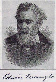
Nick Howorth writing in a magazine article (1996) says of Waugh’s Well that:
“The well, originally a spring, was converted into a memorial to Waugh in 1866.
This was an extraordinary tribute to a man who was not only still in mid-career
at the time, but who had only been famous as a writer of Lancashire dialect
songs and poems for 10 years. His fame grew to the extent that by the time he
died in 1890 he was variously called '”The Laureate of Lancashire”' or '”The
Burns of Lancashire”', although he never achieved an international reputation.
The well was rebuilt in 1966 and shows a bronze figurehead of Waugh with his
dates, 1817-1890. His connection with the spring on Scout Moor was that he often
stayed with friends living at Fo Edge Farm near the well, finding the solitude
good for composing songs and poems.
"The name ‘Waugh’ is variously pronounced in Lancashire to rhyme with ‘draw’,
‘laugh’ or cough,…..but today ‘Waw’ is more usual. Edwin was born in 1817 in a
cottage at the foot of Toad Lane, Rochdale, the second son of a prosperous
clog-maker. All was well until his father died of a fever aged 37 when Edwin was
nine years old. Years of penury followed but Edwin’s mother, Mary, held the
family together. She was a devout Methodist, intelligent, and a good singer. By
being careful, she kept Edwin at school until he was 12. She then educated him
at home herself, fostering in him the seeds of artistic talent.”
Howorth goes onto say that: “His early career was a struggle against poverty. He was
apprenticed to a Rochdale printer, Thomas Holden, when aged 14. This gave him
opportunities to read widely although he was often ‘ticked off’ for reading
during the shop hours. He also met local literary figures and politicians. Waugh
held strong Liberal views but his boss was a Tory; they did not get on well.
Between the ages of 20 and 30, Waugh worked in London and the south of England
as a printer, but in 1844 he returned to Rochdale to work at Holden’s. They fell
out over politics and Waugh left in 1847. In that year he abruptly married Mary
Ann Hill, but although he loved her deeply, their natures were so far apart that
the marriage was a disaster.
“For the next five years Waugh worked for the Lancashire Public School Association whose aim was to make a good quality primary education available to poor children. Waugh worked in Manchester, which he hated, but he met many of the city’s literary and intellectual leaders and talked literature, education and politics with other struggling writers. He was beginning to get articles and poems published in Manchester. He worked partime as a journeyman printer, earning money by printing copies of “Tim Bobbin” (John Collier’s masterpiece of 1746). In 1855 he borrowed £120 and published his first volume of essays, “”Sketches of Lancashire Life and Localities””. Then in June 1856 came the big breakthrough when “”Come Whoam to thi Childer an’ Me,”” was published in the Manchester Examiner, bringing him national prominence. The poem was republished as a penny card, earning him £5 for 5,000 cards.
“His reputation was made and he never looked back. His first collection of poems and Lancashire songs followed in 1859. A few of the titles give the flavor: '”God bless these poor folk!”', '”while takin’ a wift o’ my pipe”' and '”Aw’ve worn my bits o’ shoon away.” Apart from courtship and family life, his great love was nature. Many of his essays described excursions far beyond the Lancashire moors, such as Scotland and Ireland. Essays were often published as pamphlets selling for 6d or 1s, eg ‘Over Sands to the Lakes’, ‘Seaside Lakes and Mountains of Cumberland’, ‘Norbreck: A Sketch of the Lancashire Coast’ cost 1d. Waugh’s third area of composition was poetry in standard English. A few titles are: ‘The Moorland Flowers’, ‘Keen Blows the North Wind’, ‘God Bless Thee, Old England’ and ‘The Wanderer’s Hymn’. Subjects like these no doubt reflected the tastes of Victorian England.
Nick Howorth (1996) also adds that: “Another important Waugh activity for many years was giving public readings of his works, rather like his contemporary, Charles Dickens. Although these did not pay very well, they kept his name in the public eye. His big, open, friendly face and soft Lancashire accent made him a popular performer. He did not dress up for these public performances, was always an unkempt figure with big boots, thick tweeds and a heavy walking stick. This emphasized his humble origins to his audiences. In 1869, he read in public almost fortnightly in town halls all over the midlands and the north.
Waugh was an important figure in Lancashire’s literary history because he popularized dialect poetry and made it a valid part of English literature. Before Waugh, Lancashire dialect was difficult to follow, because it contained so many obscure words and spellings. Tim Bobbin, dating from 1746, is the best example of the “”old dialect”’. Readers have to refer constantly to the author’s glossary. Waugh simplified and standardized how Lancashire dialect should be written down, and it has hardly changed since then."
At the western edge of Broadfield Park, Rochdale, overlooking the Esplanade there is a very fine four-sided monument commemorating Edwin Waugh and three other local poets. (See photo below). This monument is called ‘The Lancashire Dialect Writers Memorial’. It was designed by Edward Sykes and erected on the land above the Esplanade in 1900. The pedestal is made of red granite and is topped by an obelisk. The four local poets are: Edwin Waugh (d. 1890), Oliver Ormerod (d. 1879), Margaret Lahee (d. 1895) and John Clegg (d. 1895). This fine memorial is inscribed with various poems and information regarding each writer, with their carved heads. A bit further along the path is a statue of John Bright (1811-1889 the Liberal MP for Manchester. Bright was a reformer and campaigner for the repeal of The Corn Laws (1839). In St Chad’s churchyard, Sparrow Hill, is the grave of Tim Bobbin alias John Collier (1708-1786), the satirical dialect poet who frequented the inns of Rochdale. His grave, with its now worn epitaph, is behind iron railings; but ‘the’ grave has become a place of pilgrimage for devotees of his life and works.
Sources/References:-
Nick Howorth, ‘Edwin Waugh – a man of ink, and his well’, Really Lancashire – A Magazine for the Red Rose County, Landy Publishing, Staining, Blackpool, Issue No. 2, August 1996.
https://en.wikipedia.org/wiki/Edwin_Waugh
http://www.edwinwaughdialectsociety.com/waugh.html
https://thejournalofantiquities.com/2018/03/04/waughs-well-scout-moor-near-edenfield-lancashire/
Copyright © RayS57, 2020.
Subscribe to:
Posts (Atom)


