
Showing posts with label Rochdale. Show all posts
Showing posts with label Rochdale. Show all posts
Saturday, 11 April 2026
THE PLACE NAMES OF ROCHDALE AND DISTRICT (and their meaning).


Monday, 26 January 2026
Spotland Bridge New Mill, Rochdale, Greater Manchester.

Tuesday, 6 June 2023
Church of St. Mary-in-the-Baum, St Mary's Gate, Rochdale, and the Legend of the Baum Rabbit.

Thursday, 29 December 2022
The Old Rochdale Market Cross in Greater Manchester.
The old cross that stands beside the Packer Spout, just opposite Rochdale Town
Hall and beside the steep steps (Church Steps) going up to the parish church of
St Chad, is fairly recent, well maybe 19th century, but the circular, stepped
and moulded base could be late medieval or post medieval in date? The base
stones are thought to be the only remaining part of the old Rochdale Market
Cross. The original open market used to be located at the bottom of Yorkshire
Street, but was moved for a time to the Town Hall Square, close-by Packer
Spout.
 In the entrance to the Touchstones Museum an ornate cross-head is on display.
Could this have once adorned the top of the present Market Cross, probably not.
The shaft of (this) cross is much more recent, but the cornice and stone sphere
(ball finial) on top could be 18th or 19th century in date, and, therefore, much
more recent than the cross-head in the museum across the road on the Esplanade,
which looks distinctly Medieval. The market cross, in its entirety, originally
stood at the bottom of Yorkshire Street back in the early 19th century.
The Packer Spout fountain, mentioned earlier, is still flowing in St Chad's
Garden and was the town's main water supply for a few hundred years or more. The
old Market Cross is Grade II listed. List Entry No: 1031929. The Ordnance Survey
Grid Reference is: SD 89641321.
Sources/References:
The illustration (above) of the Rochdale Market Cross is by courtesy of Greg
Couzens on The Original Rochdale Memories group on Facebook. Thankyou most kindly Greg.
https://britishlistedbuildings.co.uk/101031929-market-cross-milkstone-and-deeplish-ward#.Y6otz7rP3IU
https://britishlistedbuildings.co.uk/101031929-market-cross-milkstone-and-deeplish-ward/photos/21906
Copyright © RayS57, 2022.

Friday, 9 December 2022
The Celtic Stone Heads of Wardle, Near Rochdale, Greater Manchester.
Back in 1970 two carved stone heads were donated to the Rochdale Museum by a
lady living in Lowflats, Wardle, near Rochdale; she had previously had them as
garden ornaments. The two gritstone heads which stand on stone pillars had been
described as Celtic stone heads, but that is unlikely to be the case, as they
were dated to the 17th or 18th centuries, and, maybe even only as old as the
20th century! These carved heads, which had been used as gateposts in the past,
had come from different places in the Wardle area. The smaller head, which is
117cm high, apparently came from Low Farm (Low Hill) in Wardle (there was an
ancient burial mound on Low Hill), whereas the larger head, which is 148cm high,
came from nearby Howarth Farm (also called Howarth Knowl Farm). It is likely the
smaller carved head stood beside an ancient spring - where it had acted as a
lucky, symbolic talisman. The two stone heads have been on display in the
entrance area of the Touchstones Museum, the Esplanade, Rochdale since 2002.
 In an article for the Winter 2012 volume of the 'Lancashire History Quarterly'
magazine, Raymond Varley tells about the 'Two Stone Gatepost Heads from Wardle,
Rochdale, Lancashire'. He says:
"These two stone gatepost heads were donated to the Rochdale Museum in 1970
by Gertrude Jane Wilkinson of Lowflats, Wardle near Rochdale, where she kept
them in her garden for a number of years. They were then put into storage
waiting extensive renovation work to the former vicarage of the Parish Church
of St. Chad which opened as Rochdale Museum in 1975. The stone heads were then
put on display in the entrance hall. However, the museum closed in 1989 and
once again the stone heads were put into storage until a permanent and
accessible home to display them was found. This was at Touchstones Rochdale in
2002, but before being displayed, conservation work..... was carried out on
the heads, which are made from local gritstone. After they were cleaned and
restored the stone heads were placed at the entrance to the museum.
"Although the actual sites for these two stone gatepost heads is not known,
there is no doubt that they both came from Wardle, which is a small Pennine
village. It is situated at foothills of the Pennines surrounded on three sides
by high moorland country. Wardle was originally an isolated village with just
a cart track to Rochdale. It may have Celtic origins..... and Mesolithic and
Bronze Age flint tools and arrowheads have been found on Middle Hill..... and
Brown Wardle Hill, north of Wardle..... Howarth Knowl might originate from the
Anglo Saxon word 'cnoll' meaning hill top..... Immediately north of Wardle was
once the hamlet of Watergrove, which is now beneath the waves of the
reservoir."
Raymond Varley goes on to say:"These two ancient-looking stone head faces can be recognised as human,
carved at the top of gateposts. In the past stone heads were often disregarded
as a minor architectural feature and it was not until the 1960s when they
started to receive public attention. This was when Sidney Jackson, late Keeper
of Cartwright Hall Museum, Bradford, began publicising the abumdance of
primitive looking carved heads, which were turning up in the North of England
in particular Yorkshire. Press publicity also increased the awareness of stone
heads in Yorkshire. Jackson was the first to realise that the carvings were an
important and overlooked part of our historical heritage with a significant
number found throughout West Yorkshire. As a result he wrote many short
articles on their discovery in the Cartwright Hall Museum Archaeology Group
Bulletins (Jackson 1960) suggesting that they had ancient origins. This was
because the features on most of the carvings were often primitive.
"Many stone heads have been found in gardens serving as ornaments and
some were found built into dry-stone field walls. Most of them are
three-dimensional and free-standing. They also appear in buildings above
doorways, on either side of a window, or on a gable end. Other common
locations are bridges, wells and springs. Stone gatepost heads, like the ones
from Wardle however, seem to be an infrequent discovery.
Sources/References:-
Lancashire History Quarterly - Exploring The History Of Old Lancashire Volume 15 Issue No. 2 Winter 2012, Hudson History of Settle, Kirkgate, Settle, N.Yorks.
https://www.yourtrustrochdale.co.uk/venues/touchstones-rochdale/
Copyright © RayS57, 2022.

Friday, 26 March 2021
Around Watergrove Reservoir near Wardle, Rochdale, Greater Manchester
On the windswept Pennine moors to the north of Wardle, near Rochdale, in Greater
Manchester, is Watergrove Reservoir. The reservoir was constructed back in the
1930s in order to supply water to nearby Rochdale, which was short of water in
times of drought, but the old village of Watergrove very sadly had to be
abandoned and sub-merged beneath the waters of this new reservoir. Watergrove
village itself came into being in the first half of the 19th century with at
least three mills providing work for the good folk of Wartergrove and probably
some from Wardle; there was also a Methodist church, and a public house! and,
eventually by about 1870 300 people were living in the village. However,
children from the village had to go to Wardle as there was no school.
 Going further back into the history of Watergrove there were several farms
dotted around, mainly dating from the 1700s, but one from as far back as 1640.
But the cotton mills that were built in and around Watergrove after 1840 were
what undoubtedly caused the village to flourish during the 19th century. The
millworkers lived in rows of cottages in the village; they attended the church
on Sundays, and maybe went to the pub when they had the time and the money. Life
was quite good but also hard for the cotton workers here for they worked long
hours, but, the good folk of Watergrove village were a 'very big part' of the
Industrial Revolution in the Rochdale area in the Victorian Age. But, by the
early part of the 20th century the mills began to decline and by about 1930 had
finally closed; the village of Watergrove then also fell into a slow depression,
with some of its inhabitants moving away to the nearby towns, while hundreds of
local men were employed in the construction of what would be the final nail in
the coffin, the reservoir itself.
 In 1938 the once vibrant community of Watergrove had gone forever, sunk beneath
the waters of the reservoir, the foundations of its long-forgotten farms and
other buildings only reappearing when the reservoir's waters are at a very
low-level in long spells of dry weather. On the south-eastern bank of the
reservoir there is 'The History Wall' or Wave Wall with many interesting carved
stones and date-stones from the old village built into it. Today Watergrove
Reservoir is a place to go to for walking - there are indeed many paths and
trails in the area and, there are footpaths running around the edges of the
reservoir. The Rochdale Way runs just to the west. There is car-parking at the
south-side of the reservoir (SD 91169 17649). The History Wall is 100 metres
east of the carpark.
 Watergrove Reservoir is the largest in the Rochdale area and is situated some
240 metres (787 feet) above sea-level. From west to east it is 846 metres (2,775
feet) in width and from south to north 1,245 metres (4,084 feet) in length.
Sources & Related Websites:-
https://www.geograph.org.uk/photo/2289430
https://www.geograph.org.uk/photo/2290199
https://lancashirepast.com/2019/09/01/watergrove-reservoir-and-drowned-village-wardle/
http://www.abandonedcommunities.co.uk/rochdale3.html
https://www.visitrochdale.com/things-to-do/watergrove-reservoir-p12901
https://getoutside.ordnancesurvey.co.uk/local/watergrove-reservoir-rochdale
Copyright © RayS57, 2021


Wednesday, 23 December 2020
Waugh’s Well, Scout Moor, Near Edenfield, Lancashire
OS Grid Reference: SD 8287 1957. On windswept Scout Moor between Edenfield and
Cowpe in the Rossendale Valley, Lancashire, stands the Victorian memorial known
as Waugh's Well, named after the famous Rochdale-born dialect poet Edwin Waugh
(1817-1890), who was the son of a shoemaker. The poet often came to stay at a
farm on the moors and, very often would visit and sit beside a spring of water,
at Foe Edge. In 1866 a wellhead with a carved stone-head of the poet and a
gritstone wall at either side, was built to honour the man who would come to be
known as the Lancashire Poet Laureate and also Lancashire's very own "Burns".
Following his death at New Brighton the well became a place of pilgrimage for
devotees of the poet, but it was here on the moor at Foe Edge that Edwin Waugh
composed some of his famous dialect poems, all having a strong Lancashire feel
about them. The well lies about ¼ of a mile to the east of Scout Moor High Level
Reservoir on the Rossendale Way footpath. The site is probably best reached from
the A680 road and the footpath going past Edenfield Cricket Club, and then
eastwards onto the moor itself for a few miles towards Cowpe.
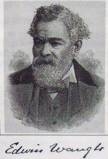 Nick Howorth writing in a magazine article (1996) says of Waugh’s Well that:
“The well, originally a spring, was converted into a memorial to Waugh in 1866.
This was an extraordinary tribute to a man who was not only still in mid-career
at the time, but who had only been famous as a writer of Lancashire dialect
songs and poems for 10 years. His fame grew to the extent that by the time he
died in 1890 he was variously called '”The Laureate of Lancashire”' or '”The
Burns of Lancashire”', although he never achieved an international reputation.
The well was rebuilt in 1966 and shows a bronze figurehead of Waugh with his
dates, 1817-1890. His connection with the spring on Scout Moor was that he often
stayed with friends living at Fo Edge Farm near the well, finding the solitude
good for composing songs and poems.
"The name ‘Waugh’ is variously pronounced in Lancashire to rhyme with ‘draw’,
‘laugh’ or cough,…..but today ‘Waw’ is more usual. Edwin was born in 1817 in a
cottage at the foot of Toad Lane, Rochdale, the second son of a prosperous
clog-maker. All was well until his father died of a fever aged 37 when Edwin was
nine years old. Years of penury followed but Edwin’s mother, Mary, held the
family together. She was a devout Methodist, intelligent, and a good singer. By
being careful, she kept Edwin at school until he was 12. She then educated him
at home herself, fostering in him the seeds of artistic talent.”
Howorth goes onto say that: “His early career was a struggle against poverty. He was
apprenticed to a Rochdale printer, Thomas Holden, when aged 14. This gave him
opportunities to read widely although he was often ‘ticked off’ for reading
during the shop hours. He also met local literary figures and politicians. Waugh
held strong Liberal views but his boss was a Tory; they did not get on well.
Between the ages of 20 and 30, Waugh worked in London and the south of England
as a printer, but in 1844 he returned to Rochdale to work at Holden’s. They fell
out over politics and Waugh left in 1847. In that year he abruptly married Mary
Ann Hill, but although he loved her deeply, their natures were so far apart that
the marriage was a disaster.
“For the next five years Waugh worked for the Lancashire Public School Association whose aim was to make a good quality primary education available to poor children. Waugh worked in Manchester, which he hated, but he met many of the city’s literary and intellectual leaders and talked literature, education and politics with other struggling writers. He was beginning to get articles and poems published in Manchester. He worked partime as a journeyman printer, earning money by printing copies of “Tim Bobbin” (John Collier’s masterpiece of 1746). In 1855 he borrowed £120 and published his first volume of essays, “”Sketches of Lancashire Life and Localities””. Then in June 1856 came the big breakthrough when “”Come Whoam to thi Childer an’ Me,”” was published in the Manchester Examiner, bringing him national prominence. The poem was republished as a penny card, earning him £5 for 5,000 cards.
“His reputation was made and he never looked back. His first collection of poems and Lancashire songs followed in 1859. A few of the titles give the flavor: '”God bless these poor folk!”', '”while takin’ a wift o’ my pipe”' and '”Aw’ve worn my bits o’ shoon away.” Apart from courtship and family life, his great love was nature. Many of his essays described excursions far beyond the Lancashire moors, such as Scotland and Ireland. Essays were often published as pamphlets selling for 6d or 1s, eg ‘Over Sands to the Lakes’, ‘Seaside Lakes and Mountains of Cumberland’, ‘Norbreck: A Sketch of the Lancashire Coast’ cost 1d. Waugh’s third area of composition was poetry in standard English. A few titles are: ‘The Moorland Flowers’, ‘Keen Blows the North Wind’, ‘God Bless Thee, Old England’ and ‘The Wanderer’s Hymn’. Subjects like these no doubt reflected the tastes of Victorian England.
Nick Howorth (1996) also adds that: “Another important Waugh activity for many years was giving public readings of his works, rather like his contemporary, Charles Dickens. Although these did not pay very well, they kept his name in the public eye. His big, open, friendly face and soft Lancashire accent made him a popular performer. He did not dress up for these public performances, was always an unkempt figure with big boots, thick tweeds and a heavy walking stick. This emphasized his humble origins to his audiences. In 1869, he read in public almost fortnightly in town halls all over the midlands and the north.
Waugh was an important figure in Lancashire’s literary history because he popularized dialect poetry and made it a valid part of English literature. Before Waugh, Lancashire dialect was difficult to follow, because it contained so many obscure words and spellings. Tim Bobbin, dating from 1746, is the best example of the “”old dialect”’. Readers have to refer constantly to the author’s glossary. Waugh simplified and standardized how Lancashire dialect should be written down, and it has hardly changed since then."
At the western edge of Broadfield Park, Rochdale, overlooking the Esplanade there is a very fine four-sided monument commemorating Edwin Waugh and three other local poets. (See photo below). This monument is called ‘The Lancashire Dialect Writers Memorial’. It was designed by Edward Sykes and erected on the land above the Esplanade in 1900. The pedestal is made of red granite and is topped by an obelisk. The four local poets are: Edwin Waugh (d. 1890), Oliver Ormerod (d. 1879), Margaret Lahee (d. 1895) and John Clegg (d. 1895). This fine memorial is inscribed with various poems and information regarding each writer, with their carved heads. A bit further along the path is a statue of John Bright (1811-1889 the Liberal MP for Manchester. Bright was a reformer and campaigner for the repeal of The Corn Laws (1839). In St Chad’s churchyard, Sparrow Hill, is the grave of Tim Bobbin alias John Collier (1708-1786), the satirical dialect poet who frequented the inns of Rochdale. His grave, with its now worn epitaph, is behind iron railings; but ‘the’ grave has become a place of pilgrimage for devotees of his life and works.
 Sources/References:-
Nick Howorth, ‘Edwin Waugh – a man of ink, and his well’, Really Lancashire – A Magazine for the Red Rose County, Landy Publishing, Staining, Blackpool, Issue No. 2, August 1996.
https://en.wikipedia.org/wiki/Edwin_Waugh
http://www.edwinwaughdialectsociety.com/waugh.html
https://thejournalofantiquities.com/2018/03/04/waughs-well-scout-moor-near-edenfield-lancashire/
Copyright © RayS57, 2020.


Wednesday, 18 November 2020
St James' Chapel, Chapel Lane Near Rochdale, Greater Manchester.
On a hilltop roughly halfway between Carr Woods (Coal Bank) and School Lane,
near Norden, Rochdale, Greater Manchester, there is an early 16th century chapel
dedicated to St James, and a graveyard. The little building stands at the top
end of Chapel Lane next to a building that used to be the Egerton Arms Inn, but
which is now a private house. There are good panoramic views from here. The
chapel is rectangular shaped and quite small in size (roughly 9m x 6m 29ft x
19ft), and has obviously been rebuilt on a number of occassions; the present
building is of 1789 though it was enlarged in 1837. St James' Chapel was built
by Thomas Holt of nearby Ashworth Hall in 1514 for the use of his tenents; Sir
Thomas, formerley of Gristlehurst, was knighted at Flodden in Scotland in 1544.
He was the first priest to officiate at St James' Chapel, Ashworth; he died in
1563. Sir Thomas's nephew, Robert, succeeded him as priest. By the early part of
the 19th century the patrons of St James' chapel were the Egerton family of
Tatton. Wilbraham Egerton (1781-1856) very likely had the Egerton Arms Inn,
formerley called Chapel House, built just opposite the chapel in the early 19th
century; and he also had the school-house built on what is now School
Lane, in 1838, for the Ashworth Estate. This building is now St James' parish
hall and it is still a pretty little building. St James' Chapel is 3 miles northwest of Rochdale town centre.
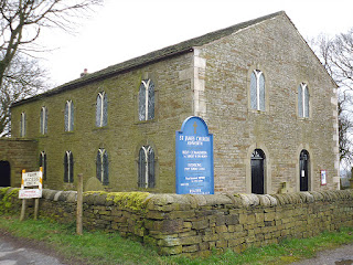 H.D.Clayton in his very interesting book 'A History of Ashworth near Rochdale' (1979), tells us more about St. James' Church: He says: "Ashworth Church is dedicated to St James, but when that dedication took place is not known. Its distance from Ashworth Hall, the ancestral home of a branch of the Holt family, would preclude the idea of its having originally been a private domestic chapel. According to the Ecclesiastical Year Book it was in existence in 1514. It was probably built during the reign of Henry VIII by the Holts for the use of their tenants. Amongst the Holt family records of 1522 occurs more than once the name of 'Sir Thomas Holt, capellanus', and it may be assumed that he officiated at Ashworth. The inventory of Church goods taken by order of Edward VI in 1552 gives details of 'one vestment, chalice and paten as belonging to a chapel called Assheworthe in the parish of Middleton.' It remained in the parish of Middleton until 1867, when it became the parish of Ashworth covering the town- ship of Ashworth. In 1559 Robert Holt left '6s. 8d. to sustentation of Ashworth Chapel to be paid when the church reeves require it.' This Robert Holt, a nephew of Sir Thomas, is thought to have been priest at the chapel from 1548-52. The Chapel is shown on Saxton's Map of 1577. Because it was a Chapel of ease to Middleton for over 300 years, it is still known locally as Ashworth Chapel.
 "The church, with the exception of the Chancel, was rebuilt and enlarged in 1789. In 1837 the Chancel, the only relic of the old building, was done away with and the east end of the Church made to assume its present shape. By this alteration and others in the gallery about 110 additional sittings were added, and the whole of the gallery, with the exception of that portion reserved for the singers, was understood to be appropriated 'henceforth and forever' for the use of the Sunday Scholars. The whole building was thoroughly repaired and wooden Gothic Mullions introduced into the windows.
 "The church as it now stands is a plain rectangular building with the rather austere interior relieved by a very fine East window, given in memory of the Rev. David Rathbone, Vicar 1832-71, and members of his family. On the wall at the east end are miniatures of the Rev. Joseph Selkirk, Vicar 1821-32, and his wife. Many gifts to the church, too numerous to mention, have been made by parishioners. The Egertons of Tatton, as patrons of the living for nearly 200 years, helped financially when necessary and gave the Font, made of stone from Mount Tabor near Halifax, in 1852; a bell which did duty from 1774 to 1895, and a silver Chalice and Paten engraved with the Egerton Arms and the date 1808. Originally the clerk's desk, reading desk and pulpit were placed one behind the other, each being raised slightly higher than the one in front of it. In some churches these three were contained in a three decker pulpit. In the 18th century this arrangement was altered and, in 1933, Miss E. Baron gave a new pulpit, the old one going to a church in Northumbria. There is an unusual memorial inside the church on the west wall. It reads: "Requiescat in Pace. Near this place rest the mortal remains of Benjamin Cass of Birtle, aged 64, and Alice his wife aged 78 obt. October 1st 1825Let the man who lives without God in his life, Give ear to the voice from the grave; Tho' he look for tomorrow, the murderer's knife May attack when ther's no one to save.We looked for tomorrow as we went to repose Thro the night on our lone humble bed. But the murderer came and the sun never rose To us - for our spirits had fled.Live then to God whilst thou livest below And to Him give each day as it flies, Prepare for the grave, that when dead thou may'st go To dwell with thy God in the skies." H. D. Clayton adds that: "Dr. Temple, Bishop of Manchester, preached at Ashworth in 1928 shortly before becoming Archbishop of York." Source / References:-


Clayton H. D., 'A History of Ashworth near Rochdale', Ashworth Hall, Rochdale, 1979.http://rochdalenorthwest.org/st-james/ https://www.familysearch.org/wiki/en/Ashworth,_Lancashire_Genealogy
Monday, 1 January 2018
Around St Chad's Church (Rochdale)
OS grid reference: SD 8964 1313. St Chad’s parish church stands upon a lofty ridge overlooking the River Roch and the town of Rochdale, Greater Manchester. The church is a very imposing edifice standing high above the equally imposing Victorian town-hall and its famous clock tower. There was a church here in either the late Saxon period, or more likely just after the Norman conquest – the mid 11th to early 12th centuries – although that is open to question. There is a well-known legend that says there were problems with the siting of the first church which was being built on lower ground on the other side of the river, and that it had to be re-sited to the higher position that we see it today. The church can be reached from opposite the Town Hall carpark and by climbing the steep 124 steps up to Sparrow Hill passing the Packer Spout on your right.

Author Dennis Ball in his interesting book 'Lancashire Pastimes' (1987) says that: "A Saxon thane, Gamel, Lord of Rochdale, decided to build a church to St Chad on the banks of the river Roche. The foundations were dug and all the materials taken to the site. All the materials mysteriously disappeared and reappeared at the summit of the steep hill on the opposite side of the river. Gamel was very annoyed and blamed his workmen. He made them take all the materials back to the original site. This took the whole of the next day. That night they were again moved back to the top of the hill. But this time the culprits were seen by some of the workmen. They were goblins."
Another, more lengthier interpretation of the legend, from the 19th century is given by J. Harland & T. T. Wilkinson in 'Lancashire Legends', which is published in 'The Secret Country' by Janet & Colin Bord. They say: "Towards the close of the reign of William the Conqueror, Gamel, the Saxon thane, Lord of Recedham or Rochdale, being left in the quiet possession of his lands and privileges, was 'minded, for the fear of God and the salvation of his immortal soul, to build a chapel unto St Chadde', nigh to the banks of the Rache or Roach. According to Mr Roby, in his 'Traditions', a place was set apart on the north bank of the river, in a low and sheltered spot now called 'The Newgate'. Piles of timber and huge stones were gathered in profusion; the foundations were laid; stakes having been driven, and several courses of rubble stone laid ready to receive the grouting or cement. In one night, the whole mass was conveyed, without the loss of a single stone, to the summit of a steep hill on the opposite bank, and apparently without any visible signs of the mode of removal. The Saxon thane was greatly incensed at what he supposed to be a trick of some of his own vassals, and threatened punishment; to obviate which, a number of the villeins and bordarii with great difficulty and labour con-veyed the building materials back to the site for the church; but again were they all removed in the night to the top of the hill. Gamel having learned the truth, sought counsel from Holy Church, and it was thereon resolved that the chapel should be built on the hill-top, as the unknown persons would not permit it to be erected on the site originally selected. This explains the chapel or church of St Chadde, still standing on a hill so high that one hundred and twenty-four steps were cut to accomplish the ascent, and enable the good people to go to prayers."
St Chad to whom Rochdale parish church is dedicated was a 7th century northern churchman who became abbot of Lastingham in Yorkshire, and for a while he was bishop of York until St Wilfrid returned from France. Later, he was made bishop of the Mercians at Lichfield. He died in 672 AD and his feast-day is held on 2nd March (Colin Waters 'A Dictionary Of Saints Days, Fasts, Feasts And Festivals'). The town of Chadderton near Rochdale is probably named after St Chad.

There are no antiquities of great age within St Chad's, although the Tudor pews are of some notable interest and parts of the church tower are 'thought' to date back to the late Saxon age, or more likely the early Norman period. The statue of St Chad high up on the outer south wall is particularly fine. The Lancashire poet John Collier (Tim Bobbin) 1708-86 is buried in the churchyard. Visit the following website/link to find more details: https://thejournalofantiquities.com/2016/04/04/st-chads-church-rochdale-greater-manchester/

Author Dennis Ball in his interesting book 'Lancashire Pastimes' (1987) says that: "A Saxon thane, Gamel, Lord of Rochdale, decided to build a church to St Chad on the banks of the river Roche. The foundations were dug and all the materials taken to the site. All the materials mysteriously disappeared and reappeared at the summit of the steep hill on the opposite side of the river. Gamel was very annoyed and blamed his workmen. He made them take all the materials back to the original site. This took the whole of the next day. That night they were again moved back to the top of the hill. But this time the culprits were seen by some of the workmen. They were goblins."
Another, more lengthier interpretation of the legend, from the 19th century is given by J. Harland & T. T. Wilkinson in 'Lancashire Legends', which is published in 'The Secret Country' by Janet & Colin Bord. They say: "Towards the close of the reign of William the Conqueror, Gamel, the Saxon thane, Lord of Recedham or Rochdale, being left in the quiet possession of his lands and privileges, was 'minded, for the fear of God and the salvation of his immortal soul, to build a chapel unto St Chadde', nigh to the banks of the Rache or Roach. According to Mr Roby, in his 'Traditions', a place was set apart on the north bank of the river, in a low and sheltered spot now called 'The Newgate'. Piles of timber and huge stones were gathered in profusion; the foundations were laid; stakes having been driven, and several courses of rubble stone laid ready to receive the grouting or cement. In one night, the whole mass was conveyed, without the loss of a single stone, to the summit of a steep hill on the opposite bank, and apparently without any visible signs of the mode of removal. The Saxon thane was greatly incensed at what he supposed to be a trick of some of his own vassals, and threatened punishment; to obviate which, a number of the villeins and bordarii with great difficulty and labour con-veyed the building materials back to the site for the church; but again were they all removed in the night to the top of the hill. Gamel having learned the truth, sought counsel from Holy Church, and it was thereon resolved that the chapel should be built on the hill-top, as the unknown persons would not permit it to be erected on the site originally selected. This explains the chapel or church of St Chadde, still standing on a hill so high that one hundred and twenty-four steps were cut to accomplish the ascent, and enable the good people to go to prayers."
St Chad to whom Rochdale parish church is dedicated was a 7th century northern churchman who became abbot of Lastingham in Yorkshire, and for a while he was bishop of York until St Wilfrid returned from France. Later, he was made bishop of the Mercians at Lichfield. He died in 672 AD and his feast-day is held on 2nd March (Colin Waters 'A Dictionary Of Saints Days, Fasts, Feasts And Festivals'). The town of Chadderton near Rochdale is probably named after St Chad.

There are no antiquities of great age within St Chad's, although the Tudor pews are of some notable interest and parts of the church tower are 'thought' to date back to the late Saxon age, or more likely the early Norman period. The statue of St Chad high up on the outer south wall is particularly fine. The Lancashire poet John Collier (Tim Bobbin) 1708-86 is buried in the churchyard. Visit the following website/link to find more details: https://thejournalofantiquities.com/2016/04/04/st-chads-church-rochdale-greater-manchester/
Wednesday, 14 March 2012
Rochdale Rambles Part 1
This is the statue of John Bright (1811-1889) a native of Rochdale. Bright was
firstly the Liberal Mp for Manchester and, in 1858, he became the
member of Parliament for Birmingham. He was a reformer and also a major
campaigner for the repeal of the Corn Laws in 1839. Also, he was
a member of The Society of Friends (Quakers) and was a mill owner in Rochdale
(his father had earlier set up this very same mill). This very fine
statue of Bright, a local landmark, stands proudly at the western side
of Broadfield Park overlooking the esplanade and close to Rochdale Town
Hall.


Just a short distance further back up the path overlooking the esplanade at
the western side of Broadfield Park stands another interesting monument called
'The Dialect Writers Memorial' made of a red granite pedestal topped by an
obelisk that was erected here in 1900. This tall granite monument stands in
memory of the four Rochdale dialect writers, Edwin Waugh who died in 1890,
Oliver Ormerod died 1879, Margaret Lahee died 1895 and John Clegg who died in
1895. However, the most famous of these undoutedly was the renowned poet Edwin
Waugh born in 1817 and died 1890 the renowned Rochdale-born dialect poet and
author. The monument is very carefully inscribed with the various poems and
information on each of the writers' - along with their carved faces. It is
well-worth having a much closer look at - and, also perhaps taking rather more
time to read those interesting inscriptions. The photo shows the side
pertaining to Edwin Waugh with related information.

From here go on into Broadfield Park - passing close to the statue of Alderman
George Leach Ashworth (1823-1873), a former mayor of Rochdale. Opposite
the bandstand and close to the St Alban's Road (Ordnance Survey grid
reference SD.896 130) entrance where there is a curious round-shaped boulder,
made of andecite, that is thought to weigh somewhere
between five and seven tons. This is actually a relic of the last
Ice-Age about 11,000-13,000 years ago. Apparently it used to lie in a
field at Cown Top farm, on the moors above Rochdale, but it was given as
a gift to the park. The glacial erratic boulder was transported to the
Rochdale area in a retreating ice flow moving south from Borrowdale in the
Lake District and scraping along the western sides of the Pennines.

Continuing our ramble around Rochdale head out of Broadfield Park and to
Sparrow Hill where the beautiful Gothic ediface of St Chad's parish church can
be found. There was a church, of sorts, here back in the 1100s on what was
perhaps a Saxon site. Part of the square-shaped tower is thought to date back
to that period. But what we see today is a Gothic revivalist restoration of
the late 19th century. The building is though quite stunning. Above the main
entrance there is an imposing statue of Saint Chad, who is looking down.

This very fine statue of St Chad, bishop of Lichfield (d 672) looks down,
imposingly, from his splendidly carved niche above the main entrance to the
church.

Close to St Chad's parish church we can see the railed-off grave of Tim Bobbin
(John Collier) 1708-1786. He was born at Urmston near Manchester and spent
much of his life in and around Rochdale, indeed he was a teacher at
Milnrow. But Collier became a well-known Lancashire caricaturist and
satirical dialect poet. He would sell his drawings and poems in the inns of
Rochdale; his portraits of the folk who frequented these ale houses were often
of a comical nature. Many of these drawings and dialect poems are still known
to us today. Collier's gravestone with its worn epitaph is a pilgrimage site
for many Lancashire poets. The worn epitaph can just be made out and has,
apparently, a number of references to his wife Mary who he referred
to as Moll.

And now the final part of our ramble takes us down 'Church Steps' 122 or 124
steps that lead down from St Chad's churchyard to the Town Hall. On descending
the steps you will see on your left 'Packer Spout' where long ago packhorses
paused for a cooling drink. At the bottom go through the carpark and there in
front of you stands Rochdale Town Hall in all its splendour. Opened in 1871 it
was built in the Victorian Gothic style by architect William Henry Crossland.
It is a fine example of a Victorian municipal building. The clock tower, a
local landmark. dominates the skyline and stands at 190 feet high and was
opened in 1888. Locally, the tower is called "Little Big Ben". The
stained-glass windows in the town hall are delightfully outstanding, in fact,
the whole building is quite stunning with its gilded lions and other features.
The interior is just as nice - if not better than the outside. It is certainly
worth spending some time and having a closer look at the building - both inside and
out.

Rochdale Town Hall clock tower is a local landmark that can be seen for miles
around. Locally it is referred to as "Little Big Ben"

Subscribe to:
Posts (Atom)