
Showing posts with label Ashworth Valley. Show all posts
Showing posts with label Ashworth Valley. Show all posts
Thursday, 30 November 2023
Ashworth Mill, Carr Woods, Near Nordon, Rochdale, Greater Manchester.


Saturday, 7 August 2021
Ashworth Colliery (Ridd Pit) on Ashworth Road, near Norden, Rochdale, Greater Manchester.
Ashworth Colliery was located on the Ashworth Road opposite Ridd Cottages on
School Lane (SD 84960 13545), near Norden, Rochdale. Also known as Ridd Pit but
some other coal mines were also on that same site: including Wheel pit, Flash
Lane pit, Crawstone Rake pit, Tramping Cat pit and Engine Pit. The Ridd shaft
was a deep pit, while the others were perhaps drift mines; the coal seams and
tunnels apparently running in all directions and, even as far as Norden! It was
operational from before 1845 until its closure in 1898. Many local men and boys
would have worked down the pit here at Ashworth during the mid 19th century,
but, very sadly some never come to the surface again as there were tragic
disasters underground. In 1842 an Act of Parliament brought an end, for the most
part, to child labour in the coal mines. There is nothing much to see of the
Ashworth Pit today, apart from the capped-off pit shaft, a grassy mound, and
some large stones which lie in the grassy field adjacent to Ashworth Road. (The
photo below shows a drift mine in the Ashworth Valley in 1890. It is probably
one of the pits at Ashworth Colliery.)
 H. D. Clayton writing in 1979 says: "The whole Ashworth area was riddled with coal mines; many were drift mines
cut into the hillside; others. like Ridd pit on Ashworth Road, were deep pits
with winding gear operated by a steam engine. The inhabitants of Moss Row in
Norden were perturbed to hears miners cutting coal beneath their homes when
the pit head was a mile away. The chimney of this pit was only felled recently
and the huge stones of the engine bed can still be seen. The coal from the
drift mines below Ashworth Hall was carried to a weighbridge at Guelder Clough
by a tramway laid along the bank of the Naden Brook, where the path now runs.
Although for years naked candles were used by the miners for light, explosion
and fire do not seem to have been a hazard. The rock is permeated by
underground streams and water was the chief danger, as evidenced by the two
disasters at Birtle in 1852 and 1884, when two mines were flooded."
(The photo below shows the site of Ashworth Colliery marked by a red arrow).
H. D. Clayton writing in 1979 says: "The whole Ashworth area was riddled with coal mines; many were drift mines
cut into the hillside; others. like Ridd pit on Ashworth Road, were deep pits
with winding gear operated by a steam engine. The inhabitants of Moss Row in
Norden were perturbed to hears miners cutting coal beneath their homes when
the pit head was a mile away. The chimney of this pit was only felled recently
and the huge stones of the engine bed can still be seen. The coal from the
drift mines below Ashworth Hall was carried to a weighbridge at Guelder Clough
by a tramway laid along the bank of the Naden Brook, where the path now runs.
Although for years naked candles were used by the miners for light, explosion
and fire do not seem to have been a hazard. The rock is permeated by
underground streams and water was the chief danger, as evidenced by the two
disasters at Birtle in 1852 and 1884, when two mines were flooded."
(The photo below shows the site of Ashworth Colliery marked by a red arrow).
 Sandiford & Ashworth writing in 1981 say:
"There were several more pits to the south where the glacial valley cut
deeply across a number of coal measures whose names, like Sand Rock Mine and
Six Inch, arose from their location rather than their character. They were
not, however, broad seams, the former being about one foot nine inches while
the latter was about one foot. To mine such narrow seams it was necessary to
remove part of the adjacent seat earth and it was suggested that this
by-product may have promoted the operation of a pottery which stood at one
time close to the present Ashworth Reservoir House.
"The position of the measures, inclined across the direction of the valley,
meant that the drift mine was common, where the coal was worked progressively
from the point at which it emerged on the surface or was approached by means
of a passage or adit rather than a shaft. As the measures frequently sloped
downwards and the entrances were often on the side of the hill, there was the
constant problem of flooding. The danger was greater where flooding occured in
disused workings and there have been several instances where miners have
accidentally broken into these workings and have been swept away by the
released water. Such was the case at Birtle Coal Pit situated some 400 yards
from the Pack Horse Inn in Elbut Lane.
Sandiford & Ashworth writing in 1981 say:
"There were several more pits to the south where the glacial valley cut
deeply across a number of coal measures whose names, like Sand Rock Mine and
Six Inch, arose from their location rather than their character. They were
not, however, broad seams, the former being about one foot nine inches while
the latter was about one foot. To mine such narrow seams it was necessary to
remove part of the adjacent seat earth and it was suggested that this
by-product may have promoted the operation of a pottery which stood at one
time close to the present Ashworth Reservoir House.
"The position of the measures, inclined across the direction of the valley,
meant that the drift mine was common, where the coal was worked progressively
from the point at which it emerged on the surface or was approached by means
of a passage or adit rather than a shaft. As the measures frequently sloped
downwards and the entrances were often on the side of the hill, there was the
constant problem of flooding. The danger was greater where flooding occured in
disused workings and there have been several instances where miners have
accidentally broken into these workings and have been swept away by the
released water. Such was the case at Birtle Coal Pit situated some 400 yards
from the Pack Horse Inn in Elbut Lane.


Northern Mines Research Society website gives the following: "The shafts at this colliery, three kilometres north of Heywood, were 122 metres deep to the Mountain Mine. It was being worked by Robert Lees, James Greenwood & James Lord in 1854. The same people probably comprised the Ashworth Coal Co. which had the colliery in 1855. Members of the Stott family owned Ashworth from 1859 to 1880. The Ashworth Colliery Co. Ltd worked it from 1885 until 1898, when it was abandoned. In the latter period, 40 persons worked underground, with seven on the surface."References & Related Websites:- Clayton H. D., A History of Ashworth near Rochdale, Ashworth Hall, Rochdale, 1979. Cole, John & Fish, Grahame, Beyond Heywood, Rochdale Metropolitan Borough Council, 1978? Sandiford, A. V & Ashwoth T. E., The Forgotten Valley, Bury and District Local History Society, 2000. https://www.nmrs.org.uk/mines-map/coal-mining-in-the-british-isles/lancashire-coalfield/rochdale-oldham-coalfield/ashworth-colliery-pre-1854-1898/ https://www.manchestereveningnews.co.uk/news/nostalgia/captain-fold-pit-disaster-1139413 Copyright © RayS57, 2021
Monday, 31 May 2021
Ashworth Fold, Near Heywood, Greater Manchester
From Simpson Clough Ashworth Road curves round the valley and further along is
Ashworth Fold at (SD 85021325), a hamlet made up of a couple of farms dating
from the 17th-18th century, some cottages of a similar date, and a 16th-17th
century hall that has an old inscribed stone and sundial in its garden. The hall
had been abandoned for a time, but it has now been made into three cottages.
Ashworth Fold is roughly situated halfway between Heywood and Norden, in Greater
Manchester. Ashworth as a place-name probably means 'Ash-trees beside a farm'.
The Naden Brook flows from Simpson Clough through Ashworth Fold and then on into
Carr Woods. A bit further along the road there was Ridd Pit or Ashworth Pit, but
this closed down in 1898 and hardly anything now remains, apart from the old
capped shaft. Opposite where this coal pit used to be are the very pitcheresque
Ridd Cottages on School Lane and the old School house just beyond, which is now
St James' parish rooms.
 H.D.Clayton writing in 1979 says:-
"The fold is the only group of buildings in Ashworth and consists of the
Hall, two farms, four cottages and the estate workshops. It is a Grade 2 group
in the list of Buildings of Architectural or Historic Interest and is
descri-bed as 'a group of buildings, mainly stone, 17th and 18th century. The
siting of the group, and features such as a late Gothic doorway, a massive
studded oak door, a stone segmented archway, an attractive parapet and finial,
a stone stile, a range of low stone mullioned windows and areas of cobbles,
combine to produce a very attractive composition. All in same style, barns
with loop lights.' The mullioned windows have disappeared, but the well-built
stone pigsties could have been mentioned. It is not known when the Fold was
built and the only clue was a date stone 1601 R.H., which used to be on a
stone pedestal placed on the ridge of the roof of Ashworth Hall farm
building.
H.D.Clayton writing in 1979 says:-
"The fold is the only group of buildings in Ashworth and consists of the
Hall, two farms, four cottages and the estate workshops. It is a Grade 2 group
in the list of Buildings of Architectural or Historic Interest and is
descri-bed as 'a group of buildings, mainly stone, 17th and 18th century. The
siting of the group, and features such as a late Gothic doorway, a massive
studded oak door, a stone segmented archway, an attractive parapet and finial,
a stone stile, a range of low stone mullioned windows and areas of cobbles,
combine to produce a very attractive composition. All in same style, barns
with loop lights.' The mullioned windows have disappeared, but the well-built
stone pigsties could have been mentioned. It is not known when the Fold was
built and the only clue was a date stone 1601 R.H., which used to be on a
stone pedestal placed on the ridge of the roof of Ashworth Hall farm
building.
 "There must have been a house on the site of the Hall from very early times
and one massive stone gable end, possibly 15th century, still stands. Some
time later this house was greatly enlarged to form a mansion, half-timbered
lath and plaster, with a wing of three gables running back to the road, and
forming a courtyard with the present two cottages and farm buildings. At the
entrance was a square tower and wicket gate, and, on the other side of the
house, a rose garden terrace, orchard and ornamental pond. At a later date the
wing and tower were removed and the half-timbered walls replaced with hand
made bricks. The original stone built house with mullion windows was left
intact, although the mullions have since been removed".
Clayton goes on to say:
"Rev. D. Rathbone recorded how the hall appeared about 1830: 'The Hall still
retains its aspiring site, its gables still peep from the woods that environ
it, but much has been destroyed, and the strong stone-built gateway with its
massive doors and wicket gatestands alone; the eastern side of the quadrangle
is gone, and nothing now remains but that southern portion which fronts the
dilapidated terrace with its moat and hanging garden. A hundred yew trees,
tradition says, once grew in stately avenues or in sombre groups around the
deserted house of many generations, but only a few survive; they stand single
and forlorn. The ruins of Ashworth Hall afford a pleasing specimen of that
style of domestic architecture which has in its many peculiarities a
distinction and beauty which bore the antiquarian and the lover of the
picturesque gives it a more than ordinary character of interest. Nothing
remains to guide us as to its age, but, judging from general appearance, we
should not hesitate to affix a date at least coeval with the Wars of the
Roses. Parts of the building may be more ancient, for there is a diversity of
style and character.'
"Two thirds of the Hall was let to the Vicar at a nominal rent and the
remainder was the farmhouse for the Hall Farm. A stream ran under this portion
of the house and beneath the floor a small waterwheel provided power as
required. In the garden are a large upright stone inscribed 'R.H. 1685' for
Richard Holt and an undated sundial on a graceful stone pedestal. Although
much altered from the age of the horse, when chain horses were kept at Guelder
Clough to help carts up the hills, and the large open space in the Fold was
covered with grass, with a stone trough in the middle, overhung with a large
cherry treeand seat for gossip, the Fold is still picturesque and beloved by
artists."
Clayton, H.D., A History of Ashworth near Rochdale, Ashworth Hall, Rochdale, 1979. The two images (above) are taken from this book.
https://historicengland.org.uk/listing/the-list/list-entry/1084283
https://historicengland.org.uk/listing/the-list/list-entry/1084285
https://www.heywoodhistory.com/2017/04/north-heritage.html
https://www.heywoodhistory.com/2016/11/mines.html
https://www.realrochdale.co.uk/editions/spring-2020/take-a-walk-in-ashworth-valley/
Copyright © RayS57, 2021
>
"There must have been a house on the site of the Hall from very early times
and one massive stone gable end, possibly 15th century, still stands. Some
time later this house was greatly enlarged to form a mansion, half-timbered
lath and plaster, with a wing of three gables running back to the road, and
forming a courtyard with the present two cottages and farm buildings. At the
entrance was a square tower and wicket gate, and, on the other side of the
house, a rose garden terrace, orchard and ornamental pond. At a later date the
wing and tower were removed and the half-timbered walls replaced with hand
made bricks. The original stone built house with mullion windows was left
intact, although the mullions have since been removed".
Clayton goes on to say:
"Rev. D. Rathbone recorded how the hall appeared about 1830: 'The Hall still
retains its aspiring site, its gables still peep from the woods that environ
it, but much has been destroyed, and the strong stone-built gateway with its
massive doors and wicket gatestands alone; the eastern side of the quadrangle
is gone, and nothing now remains but that southern portion which fronts the
dilapidated terrace with its moat and hanging garden. A hundred yew trees,
tradition says, once grew in stately avenues or in sombre groups around the
deserted house of many generations, but only a few survive; they stand single
and forlorn. The ruins of Ashworth Hall afford a pleasing specimen of that
style of domestic architecture which has in its many peculiarities a
distinction and beauty which bore the antiquarian and the lover of the
picturesque gives it a more than ordinary character of interest. Nothing
remains to guide us as to its age, but, judging from general appearance, we
should not hesitate to affix a date at least coeval with the Wars of the
Roses. Parts of the building may be more ancient, for there is a diversity of
style and character.'
"Two thirds of the Hall was let to the Vicar at a nominal rent and the
remainder was the farmhouse for the Hall Farm. A stream ran under this portion
of the house and beneath the floor a small waterwheel provided power as
required. In the garden are a large upright stone inscribed 'R.H. 1685' for
Richard Holt and an undated sundial on a graceful stone pedestal. Although
much altered from the age of the horse, when chain horses were kept at Guelder
Clough to help carts up the hills, and the large open space in the Fold was
covered with grass, with a stone trough in the middle, overhung with a large
cherry treeand seat for gossip, the Fold is still picturesque and beloved by
artists."
Clayton, H.D., A History of Ashworth near Rochdale, Ashworth Hall, Rochdale, 1979. The two images (above) are taken from this book.
https://historicengland.org.uk/listing/the-list/list-entry/1084283
https://historicengland.org.uk/listing/the-list/list-entry/1084285
https://www.heywoodhistory.com/2017/04/north-heritage.html
https://www.heywoodhistory.com/2016/11/mines.html
https://www.realrochdale.co.uk/editions/spring-2020/take-a-walk-in-ashworth-valley/
Copyright © RayS57, 2021
>


Thursday, 21 December 2017
Around Wind Hill (Cheesden) near Rochdale
OS Grid Reference: SD 83262 14945. In a farmer’s field at the side of Ashworth
road, Cheesden, near Rochdale, Greater Manchester, is Wind Hill Cairn, dating
from the Beaker Period of the Bronze Age. Now it is nothing more than a low,
grassy mound at either side of the more recent drystone wall. The cairn stands
at the north side of Wind Hill, 298m above sea-level and overlooking Knowl Moor,
with Knowl Hill itself rising over to the east beyond Edenfield road. A little
further down the lane is Ashworth Moor Reservoir and, on the opposite side of
Edenfield Road, is the famous Owd Betts public house. The cairn is in a damaged
condition due partly, at its north-side, to farming, but on its south-side there
is less damage and has, therefore, kept its circular identity. There is a
footpath heading east across Wind Hill from Ashworth road, just above Wind Hill
farm and the wind turbine, but the cairn is partly on private land (at its
northern-side) where there is a locked metal gate next to the wall – beside the
Ashworth road.
 Originally Wind Hill Bronze Age cairn had a diameter of 10.45m (34 feet) and
a height of 0.75m (2-3 feet) but it is now less than that due to
destruction at its N side. According to the
‘Lancashire Archaeological Bulletin’
(1984) with the primary reference: Tyson, N (1972) at the end of
the excavations by Bury Archaeological Group between 1968-72: this
is a ruined cairn with a kerb of horizontal slabs. There was an opening to the
E which was 6 feet wide with a subrectangular area outside that was
defined by inward-leaning slabs that are further enclosed by a “satellite
kerb”. Both of these kerbs were finally concealed. No grave pits were
found, but at the cairn’s centre a flint knife, pebble hammer and a V-bored
‘jet’ button were discovered. Further to this information: there was a
cist of sand-stones at the E side. The central and W parts of the cairn
were denuded; the E and S sides were in a better condition and still
visible. The dry-stone wall running in a straight-line through the middle of the
mound ‘was’
dug deep into the structure, causing further destruction, and some of the
stonework from the cist may have ended up in the wall itself, or could
still be in ‘situ’ in the mound?
Originally Wind Hill Bronze Age cairn had a diameter of 10.45m (34 feet) and
a height of 0.75m (2-3 feet) but it is now less than that due to
destruction at its N side. According to the
‘Lancashire Archaeological Bulletin’
(1984) with the primary reference: Tyson, N (1972) at the end of
the excavations by Bury Archaeological Group between 1968-72: this
is a ruined cairn with a kerb of horizontal slabs. There was an opening to the
E which was 6 feet wide with a subrectangular area outside that was
defined by inward-leaning slabs that are further enclosed by a “satellite
kerb”. Both of these kerbs were finally concealed. No grave pits were
found, but at the cairn’s centre a flint knife, pebble hammer and a V-bored
‘jet’ button were discovered. Further to this information: there was a
cist of sand-stones at the E side. The central and W parts of the cairn
were denuded; the E and S sides were in a better condition and still
visible. The dry-stone wall running in a straight-line through the middle of the
mound ‘was’
dug deep into the structure, causing further destruction, and some of the
stonework from the cist may have ended up in the wall itself, or could
still be in ‘situ’ in the mound?
 In 1905 a Late Bronze Age socketed axe (palstave) was dug up by workmen building the Ash-worth Moor Reservoir, just along the road from Wind Hill cairn. There have also been a number of archaeological finds on Knowl Moor and on Knowl Hill itself including arrowheads in a variety of shapes: lozenge, leaf, stemmed and barbed, and many flints in varying sizes and a thumbstone. It would seem, though, that these finds have not originated from ‘settlements’, but from pre-historic man simply roaming the higher ground above the forested areas beside the river Roch – where today we see the highly populated towns of Rochdale, Heywood and Bury. On Hamer Hill (Rooley Moor) above the town of Rochdale – some recumbent stones were recently discovered which has led archaeologists to consider the distinct possibility that they form a stone circle, and on nearby Hunger Hill there are possible burial mounds. There have also been a number of coin finds from the Roman period in the Rochdale and Heywood areas.
Sources & References:-
https://thejournalofantiquities.com/2017/03/29/wind-hill-cairn-cheesden-near-rochdale-greater-manchester/
http://www.buryarchaeologicalgroup.co.uk/windhill.html
Lancashire Archaeological Bulletin, Vol 10, No. 2/3, May & July, 1984.
Tyson, N., A Bronze Age Cairn at Wind Hill, Heywood, Lancs. Bury Archaeological Group, 1972.
Copyright © RayS57 2017.
In 1905 a Late Bronze Age socketed axe (palstave) was dug up by workmen building the Ash-worth Moor Reservoir, just along the road from Wind Hill cairn. There have also been a number of archaeological finds on Knowl Moor and on Knowl Hill itself including arrowheads in a variety of shapes: lozenge, leaf, stemmed and barbed, and many flints in varying sizes and a thumbstone. It would seem, though, that these finds have not originated from ‘settlements’, but from pre-historic man simply roaming the higher ground above the forested areas beside the river Roch – where today we see the highly populated towns of Rochdale, Heywood and Bury. On Hamer Hill (Rooley Moor) above the town of Rochdale – some recumbent stones were recently discovered which has led archaeologists to consider the distinct possibility that they form a stone circle, and on nearby Hunger Hill there are possible burial mounds. There have also been a number of coin finds from the Roman period in the Rochdale and Heywood areas.
Sources & References:-
https://thejournalofantiquities.com/2017/03/29/wind-hill-cairn-cheesden-near-rochdale-greater-manchester/
http://www.buryarchaeologicalgroup.co.uk/windhill.html
Lancashire Archaeological Bulletin, Vol 10, No. 2/3, May & July, 1984.
Tyson, N., A Bronze Age Cairn at Wind Hill, Heywood, Lancs. Bury Archaeological Group, 1972.
Copyright © RayS57 2017.


Tuesday, 24 April 2012
Around The Ashworth Valley
Please join me for a ramble through the Ashworth Valley, near Norden, Rochdale. We will walk through the valley itself, which takes in Chapel Lane, School Lane, Carr Woods, Coal Bank mill and Black Pits chimney. On the way there we will take a look at photos showing the ruins of what was once a rich and thriving industrial area - in particular we will look at Coal Bank mill and bleach works in Carr Woods, where the lovely Naden Brook flows, in what is now a very picturesque place, hidden deep inside the woods and where old industrial ruins merge in with the flora and fauna - as if time has stood still even though the industrial revolution and Coal Bank mill have been almost obliterated from what is now a "very" tranquil place.
Our little ramble starts at St James' Church on Chapel Lane (SJ8506 1390). The chapel dates from the early 1500s, being built by the Holt family of Ashworth Hall for their tenents. Go past the pub (Egerton Arms, now a private house) and turn left onto Ashworth Road and then left again onto School Lane to look at Ridd Cottages and the old school/parish hall. The tiny school-house was built by Wilbraham Egerton in 1838 for the Ashworth Estate. It closed in 1900. Today it is St James' parish hall. Carry on along School Lane to Carr Woods. At the bridge over the Naden Brook notice a gated driveway on the right-hand side. Here was the entrance to the former Carr Woods tea rooms (now a private residence). Now go back up the lane a bit and take the footpath on the right- hand side (between the two gates) and walk along here through the woods beside the steep-sided, precarious bank along which the Naden brook flows. Follow this path, which is a former tramway, for half a mile until you reach a modern curved wooden bridge. Here Mill Croft brook joins the Naden brook at Wolstenholme Fold, near Norden.




Copyright © RayS57, 2012 (Updated 2023).
Our little ramble starts at St James' Church on Chapel Lane (SJ8506 1390). The chapel dates from the early 1500s, being built by the Holt family of Ashworth Hall for their tenents. Go past the pub (Egerton Arms, now a private house) and turn left onto Ashworth Road and then left again onto School Lane to look at Ridd Cottages and the old school/parish hall. The tiny school-house was built by Wilbraham Egerton in 1838 for the Ashworth Estate. It closed in 1900. Today it is St James' parish hall. Carry on along School Lane to Carr Woods. At the bridge over the Naden Brook notice a gated driveway on the right-hand side. Here was the entrance to the former Carr Woods tea rooms (now a private residence). Now go back up the lane a bit and take the footpath on the right- hand side (between the two gates) and walk along here through the woods beside the steep-sided, precarious bank along which the Naden brook flows. Follow this path, which is a former tramway, for half a mile until you reach a modern curved wooden bridge. Here Mill Croft brook joins the Naden brook at Wolstenholme Fold, near Norden.


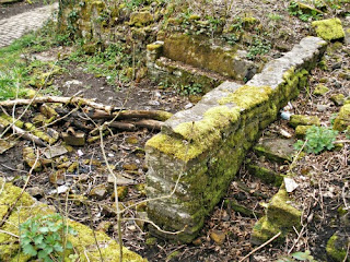
Here at Coal Bank in Fester Clough (Ordnance Survey Grid Reference: SD 85592 14167) we have now reached the objective of our ramble the site of a cotton-spinning mill beside the Naden brook. Although the cotton spinning mill-cum-bleach-works has been almost obliterated - if you look closely you can still find the ruins of this one-time industrial enclave. In the 19th century the place began life as a cotton spinning mill, but in the late 19th century the mill became a bleach works. Then in the early part of the 20th century the works closed down for good after a fire consumed the building in 1916. Much of the mill building was then pulled down and great quantities of the stonework taken away to local places. Part of a wall still stands as do the foundations of buildings, including the lodge? The Coal Bank mill chimney has recently been pulled down and the site levelled somewhat in order to make way for new pathways and modern wooden bridges - and to make a nice place to stroll and enjoy one's self in this peaceful place.


Now follow the path across the little bridge and turn to the left in the direction of the Black Pits Chimney and the Norden bus terminus. The very tall chimney is, now very sadly, all that remains of the Black Pits cotton-spinning mill that had flourished during the 19th and the early 20th century. A new modern housing estate now fills this once thriving industrial valley along which flows the Naden brook. Notice also a spring of water flowing into a water trough at the side of the footpath; this would have been used by thirsty horses pulling carts along the cobbled trackway. We now reach the end of our ramble.


Copyright © RayS57, 2012 (Updated 2023).
Friday, 9 March 2012
Ruined chimney at the Coal Bank cotton-spinning mill in Carr Woods about 1980.

The Coal Bank cotton-spinning mill complex beside
the Naden brook, in Carr Woods, near Norden, Rochdale, Greater
Manchester, which is also known as Fester Clough at Ordnance
Survey Grid Reference: SD 85592 14167 came into use in the 1800s,
but, then later it became a bleach works - one of many in this area - such as for
example the Deeply Vale Mills. The Coal
Bank mill finally closed down in the early part of the 20th
century.The photo (above) shows the old brick chimney belonging to the works,
which was, sadly, pulled down in 2006.
This colour photo shows the cobbled and flagged walkway over the Naden brook at the
site of Coal Bank mill in Carr Woods (Wolstenholme Fold), near
Norden. The photo is from the 1980s when the place was being tidied up. Some
of the ruins still quite visible at either side of the path and brook.

A rough map drawn by myself, from memory, in the late 1970s of Carr Woods
showing where the Coal Bank mill was located and the ruined chimney
etc. I have put the ruined buildings on to show the probable likely location, again
from memory. [Map not to scale]


Subscribe to:
Posts (Atom)